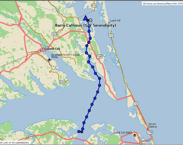
First Day: Little Alligator River anchorage to Currituck Bay Anchorage. Distance: 36 nm/Time 7 hrs
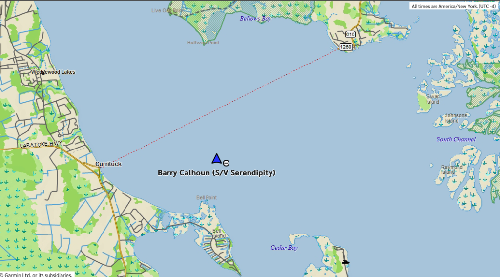
Second Day: Currituck Bay Anchorage
It’s been a rough couple of days. First, a very hot day of motoring yesterday, which also included a electrical system failure, followed by 24-hours of rain in a very hot and stuffy cabin, in a boat being tossed around by 15 knots of wind and 2-foot seas.
On Sunday, I got up early to do some route planning based on the forecast weather. The winds for the day were forecast to be out of the south/southwest at only about 6 knots, until the afternoon, when there were supposed to be rain showers and thunderstorms for the following 24 hours or so–until Monday late afternoon. Then the winds would clock to the northeast and increase to 15 knots or so, and then increase during Monday night to almost 20 knots for the following few days.
So, I was considering whether to remain at the Little Alligator Creek anchorage for another day to let the thunderstorms pass. The problem was that there was a ton of fetch1 from the northeast where I was–all the way across Albemarle Sound. It would get nasty having 12-15 miles of fetch. But, I also didn’t want to get caught in the ICW in any thunderstorms if I could help it.
The other big problem with the section of ICW from Oriental to the Chesapeake is that anchorages are very few and far between, and even less so for a boat with my draft. In this case, there was only one appropriate anchorage for the next 78 miles, and it was barely appropriate. And that was a fairly exposed one in Currituck Sound, about 36 miles away. Fatigue-wise, I had generally limited myself to 40 miles, which was eight hours behind the wheel. Even if I didn’t have fatigue limitations, there were only 13 hours of daylight, which would only get me 65 miles, so I pretty much had to stop at Currituck (if I didn’t want to spring for a marina slip somewhere, which wasn’t in the budget).
The problem with the Currituck anchorage was that it was also exposed, especially from the northeast.
So, I decided to launch ASAP to hopefully get to the Currituck anchorage before the thunderstorms started, then leave early the next day. The southeast winds on Sunday were not forecast to be very strong, so the mile and a half of fetch should create too big of a problem, and I would leave Monday morning and be out of the sound before the northeast winds got very strong. After that, I would be in the narrow ICW (i.e., no fetch), so waves wouldn’t be an issue. (Like all plans, this one fell apart within a few hours.)
So, I departed the Little Alligator River anchorage around 8:15 am and almost immediately began crossing Albemarle Sound.
For a day that was supposed to be relatively cool, it didn’t feel that way at all. The temperatures were in the upper-80’s, but the main problem was the wind. Or at least, the lack of apparent2 wind. For most of the day it was from the south/southwest at about 6 knots. I was heading north/northeast at, you guessed it, about 6 knots. That made the wind over the boat basically zero. Until the afternoon, the sky was cloudless, so the sun just baked. It felt very hot all day long–completely different from yesterday’s cool breeze over the boat. (The winds were off my nose then.) And, the bugs seemed to find their way to the boat, even in the middle of the 12-mile-wide Albemarle Sound! I had to keep the hatches closed to prevent the cabin from being infested with horse flies, regular flies, midges, and small biting flies which only made it even stuffier inside.
Shortly after getting to the other side of the sound and proceeding north again in the narrow ICW, I realized that my engine’s alternator wasn’t charging my lithium batteries! The way my electrical system is set up is that my engine’s alternator charges its 12-volt, lead acid starting battery. Once that is topped off, it normally then charges my lithium (house) batteries3 via a “DC to DC Charger”. However, this charger is not providing any power to my lithium batteries for some reason. Thus, they are only being charged by solar (which isn’t enough, especially when using the autopilot all day.) It worked fine the previous two days, though, so it is strange.
While I was motoring, my son, Nicholay, and I texted back and forth for a few hours trying to troubleshoot it. (He’s a huge help because while I installed the system, he designed it.) I did things like forcing the charger into different modes, covering up all the solar panels, powering it down and back up, reprogrammed the settings a few different ways, checked all circuit breakers and continuity, and even shutdown the entire electrical system to see if it would reset. Nothing worked. It appears that the DC-to-DC charger is bad, which means I have to call the manufacturer. Unfortunately, they are in England! In the meantime, it makes cruising much more difficult since I will have to find another way to top off my batteries every few days. The only option there, of course, is a marina, which are very costly.
****************************
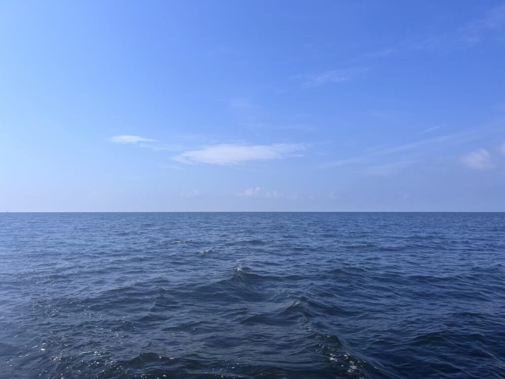
But, getting back to the trip…. The scenery yesterday was very similar to the day before’s, except for Albemarle Sound, which was a pretty boring 2 1/2 hour trip with nothing to see except water.
The only other thing of interest on the trip was passing a place called Coinjock. It has a “must stop” reputation because of a steak house with evidently monstrously huge steaks. It also has a marina and fuel. It is also very strategically placed in the middle of the dearth of anchorages along this route. However, I did not need to stop, didn’t want to pay their $3/foot transient slip fee (which equates to about $150 per night!), and so just passed them by. They were surprisingly deserted, especially for a holiday weekend.
As I got to within 30 minutes off my anchorage in Currituck Sound, I could see that as forecast thunderstorms were building a lot to my west and heading my way. I pulled up my weather radar app and noticed that a big one was approaching my anchorage and another was going to pass behind me. In other words, if I slowed down, I might pass in between them. The next line after those was far off to the west, which would hopefully allow me to get the anchor set and the boat buttoned up before that next set hit.
So, I slowed my speed to about 2 knots to wait for the cell to pass from left to right in front of me. There was a problem, though: The ICW was very narrow at this point (like only 50 feet!). Well, the actual channel markers were a normal width, but the software that I used had the U.S. Army Corps of Engineers’ sonar overlays in it, and they showed a lot of shoaling on both sides of the channel, effectively making the navigable part only 50 feet wide.
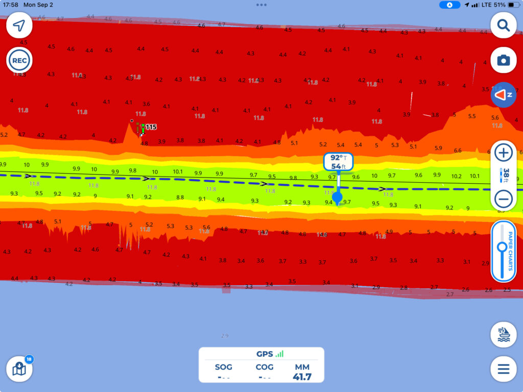
As it got closer, the outflow from the storm became so strong that it started blowing me towards the shoals on the eastern side of the ICW. This normally wouldn’t happen except that at my low speed my keel & rudder weren’t getting much water flow over them and so weren’t very effective. So, like an airplane in a stiff crosswind, I was forced to “crab” down the ICW, my nose pointing about 40 degrees off to my left, even though I was traveling along on the right side of the channel. No big deal.
Until another boat started coming the other way. Although I was already as far to the right of the channel as I dared based on the USACE data, it probably looked to him like I was almost in the middle of the channel (especially if he didn’t also have the USACE overlays). And, not only was I almost in the middle of the channel, I was pointing off towards the opposite side of it! I realized that my behavior was going to do nothing but cause a ton of confusion, so I gave up on trying to stay dry, hit the throttle, and now that the wind wasn’t causing me to slide sideways as much, could straighten out and aim straight down the channel, passing the other sailboat port to port. My perfect plan to avoid getting wet was indeed foiled (It’s always other people who ruin my perfect plans!) 🙂 and I ended up hitting the tail end of the passing storm. But, it passed quickly, and I managed to get anchored and closed up right before the next line hit.
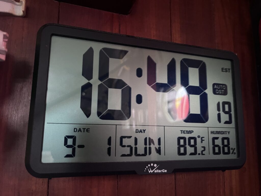
And that’s where the misery started. Because my boat was now heat-soaked after being in the sun all day. The interior temperature was 89 degrees, but I had to close all the windows and hatches because of the rain. And the showers didn’t stop for hours. It was miserable, trying to stay cool in such a hot and humid environment with just a fan. It was too hot to sleep, too hot to cook. I was glad for one thing: I had definitely made the right decision to stay in the Oriental marina (with my air conditioning) during August. Having to deal with a month of what I was experiencing would have been absolute misery!)
The temperature finally dropped below 80 degrees in the boat around midnight, when I was able to get some sleep with some gentle rocking from the westerly 8-10 knot winds.
**********************
I woke up on Monday morning to more rain showers (which had continued unabated through the night). They were forecast to stick around, on and off until late afternoon.
I spent Monday catching up on dirty dishes, making a salad, doing some blogging, but mostly troubleshooting my DC-to-DC charger to figure out why my batteries weren’t charging.
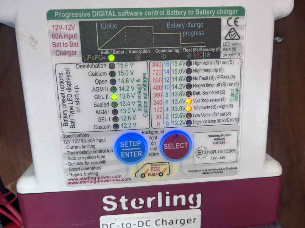
This involved a number of FaceTime calls to Nicholay in Guatemala, emptying out both cockpit lockers to crawl inside to throw various switches, making multiple settings changes to the charger itself, and running the engine occasionally to see if anything would solve the problem. Of course, all of this had to be carefully timed to coincide with the small windows between the passing rain showers. These intervals also involved running around the boat opening all the portlights and hatches to get some airflow through the boat, then closing them again when the next band would come through. It was a tiring day. The only saving grace was that the temperature never got above 80 degrees all cloudy day.
By the end of the day, I think Nicholay and I had figured out that it likely wasn’t the DC-to-DC charger at all, but a bad connection somewhere in the wiring. I would have to do through the system and check connections. But that would have to wait for another day when I was fresh.
In the meantime, the rain had finally stopped, the sun had come out, and the wind had clocked around to the northeast and had started building.
This wasn’t good. The forecast was calling for the winds to increase in the afternoon, then abate a bit in the morning, then increase more during the night, then really kick into gear starting Tuesday morning.
With just two foot rollers coming through, I could see that it was going to be difficult to sleep. And that was with about 12 knots of wind. If the winds picked up to 20 knots as forecast on Tuesday, and would be continuing for a few days, I really didn’t think this anchorage would be tenable. I started getting worried.
It was too late in the day to think about moving until morning. The problem was where to go? I really didn’t want to keep cruising without a way to charge my batteries; they were already down to 55% and would be lower by morning. The only other option than heading north for another day to another questionable anchorage (with this wind direction) was to turn around and head back to Coinjock Marina, about an hour south. In light of the electrical issues and the weather, (and in spite of it busting my budget), I decided that was the prudent thing to do.
I have them a call just before they closed to find out their rates. It would be $2.75 per foot, plus $12 for electricity, which meant about $140 with tax per night. I knew I would need two nights. I didn’t make a reservation then, but told them I’d probably be calling them in the morning.
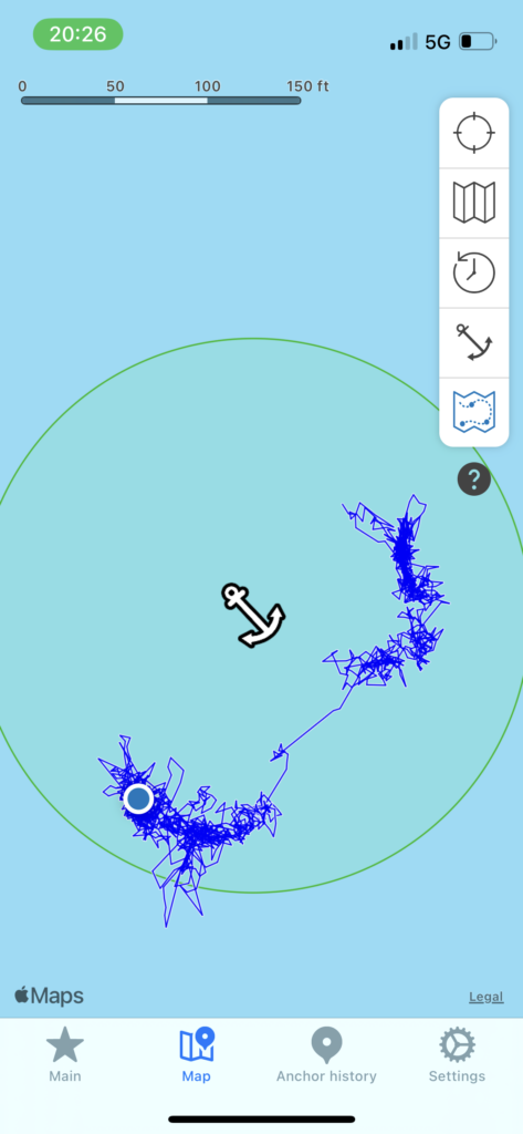
What worried me most when going to bed was dragging anchor. I double checked the depth sounder, and was in 7.8′ of water, so that was fine. But, with the higher winds and associated higher waves (especially with the much longer fetch now that the winds had clocked to the northeast), I was worried about dragging. So, I re-organized all the cockpit locker debris in the cockpit so I could easily get to the engine controls and helm, then made a clear path to the anchor as well.
I was also worried a bit about my snubber. I had attached it to the cutwater with an eye splice. I did a pretty good job at it, but it wasn’t perfect. I thought about what would happen if it came undone during the night. All the strain, the jerking of the bow moving up and down, would be taken directly by the gypsy on the windlass, which would likely damage the windlass. So, , I decided to attach another line to the anchor chain on deck using a rolling hitch, then attaching the other end of the line to a deck cleat. At least it would take the strain and hopefully give me time to work something out if the snubber did come undone. I then rechecked my anchor alarm maps to ensure that we hadn’t drifted. In spite of the higher winds, the anchor was holding firm so far.
With everything I could think of having been done, I went to bed, hoping that I’d be able to get at least a little bit of sleep.
- The distance the wind has to act on a given body of water. All things being equal, the greater the distance, the bigger the waves. The wave size can also increase with a given wind if it has more time to act on a given body of water (up to a certain limit). ↩︎
- Sailors talk about two kinds of wind: True and Apparent. True is the wind in relation to the earth. For example, blowing from the north at 10 knots. Apparent wind is how it feels on the boat. For example, if the True wind is from the north at 10 knots, but the boat is moving east at 10 knots, it will feel on the boat like the wind is coming from the northeast. Aviation has the same thing, but terms it relative wind. ↩︎
- The house batteries run all the electrical systems on the boat, including refrigeration, lights, fans, autopilot, GPS, radios, depth sounders, wind sensors, ice maker, water pumps, etc. ↩︎